
PureInsight | January 25, 2024
[PureInsight.org]
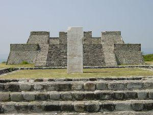
El Tajin Ancient City: Niched Pyramid
The most famous site in the El Tajin pre-Hispanic city is the Niched Pyramid. The tower is a square seven-layer cake, with each side of the base measuring about 40 meters. The pyramid is about 18 meters tall, with a base length of 27 meters. On the east side of the pyramid, there are steep stone steps leading to the top, but the uppermost layer is already damaged.
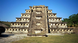
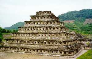
Each level of the pyramid has wide eaves on the upper side and concave niches on the lower side. The eaves protrude over the niches, creating an incredible contrast of light and shadow. There are also remnants of red, blue, and black colors on the tower.
The 365 square niches on the pyramid represent each day of the year, and thus, the Niched Pyramid has both religious and calendrical significance.
Local indigenous people built the Niched Pyramid in the 5th century AD, and despite being over a thousand years old, it is still well preserved today. The majestic and grandiose characteristics of the pyramid's construction showcase the ancient indigenous people's vitality and creativity, making it one of the most beautiful examples of ancient architecture.
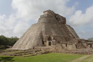
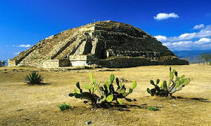
Uxmal: Pyramid of the Magician
The Uxmal ancient city was inhabited since before the Common Era and was founded in the 7th century. Over the following two hundred years, it reached its zenith, with a population of up to 25,000, making Uxmal the largest city and religious center on the Yucatan Peninsula. After being influenced by Toltec culture in the 11th century, Uxmal gradually declined and was abandoned in the late 15th century.
The Pyramid of the Magician, located in Uxmal, is one of the most impressive structures in the city. According to Mayan legend, the pyramid was built in a single night by a dwarf magician who then became the ruler of the city. The pyramid has five levels, with the top level standing at around 35 meters high. Unlike most pyramids in Mesoamerica, the Pyramid of the Magician has an oval base shape, which adds to its unique charm.
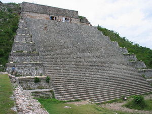
The Back of the West-facing Stairs
Uxmal, which means "three times rebuilt" in the Mayan language, has actually been rebuilt more than three times, with its main buildings undergoing repeated repairs and renovations over the years, resulting in different architectural styles. The highest structure in Uxmal, the Pyramid of the Magician (Piramide del Adivino), has been rebuilt five times.
The layout of the ancient city is unique, with the main buildings arranged according to the positions of the planets known at the time, with the building representing Venus located in the most prominent position. The site of this building complex was arranged in a pattern of four rectangular buildings surrounding a central courtyard.
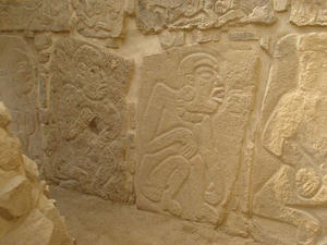
Uxmal is known for its intricate stone carvings, although they are slightly rough compared to the ancient Eastern reliefs of Angkor Wat, Borobudur, and Patan in Nepal. However, one cannot generalize about different ancient civilizations, as these meticulously planned and grandiose architectural complexes are already miracles in the history of ancient civilization development.
According to ancient myths and legends, a diviner appointed by God named Itzamná built this giant structure, which stands at 38 meters tall, in one night. It is called the "Pirámide del Adivino" or "Pyramid of the Diviner," but in reality, it took more than 300 years of construction to complete.
The Pyramid of the Diviner is located on the east side of the entrance to Uxmal and is a unique stepped pyramid. The base is oval, longer from east to west, and consists of three gradually decreasing levels. Above the 118 steps is a temple, with the west-facing steps leading directly to the central doorway of the temple. In ancient times, priests performed astronomical divination, predicted the future, and held various rituals and ceremonies of all sizes in the temple on the top of the pyramid.
The design of the Pyramid of the Magician is precise. At the moment of sunset on the summer solstice, the western steps of the pyramid are always aligned with the sun's rays, indicating that the ancient indigenous people understood precise astronomical calendars.
Tulum ancient city ruins
The Tulum archaeological site is an important late Mayan culture ruin, located on the northeast coast of the Yucatan Peninsula, perched on the edge of the cliffs along the Caribbean Sea.
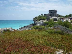
The name of the ancient city "Tulum" has a colonial cultural connotation. "Tu" in Spanish means "stone" and "Lum" means "wall", together they mean "stone wall". The city is surrounded by walls with a thickness of about 5 meters on three sides, facing the sea on one side. The whole stone city is well-planned.
It was built in the 10th century and flourished in the 12th to 14th centuries, with an estimated population of 100,000 at that time. It was a religious city in the late period of the Mayan culture in the 14th century. Inside the walls, there are several temples for sacrifice and palaces for the nobility. The upper-class nobles and clergy lived in the city, while ordinary Mayan people lived outside the city.
In 1519, when the Spanish colonizers invaded Mexico, Tulum was also occupied. At the end of the 16th century, the Maya people abandoned the city. The Tulum temples had a high status in the hearts of the Maya people.
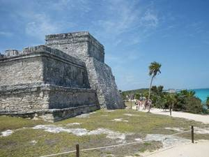
The current ruins are well preserved, with over 60 stone buildings. The largest building in the city is the Temple of Kukulcan (also known as El Castillo), along with the Temple of the Descending God and the Temple of the Frescoes. In addition to the temples, there are dozens of stone buildings such as palaces and colonnades.
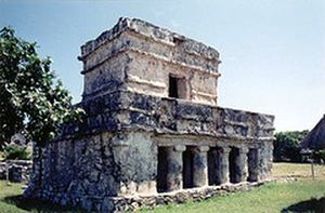
The most famous structure is the "Castillo" grand temple, standing tall on a cliff over 12 meters high. In addition, the "Templo de las Frescos" temple is also well-preserved, becoming a major tourist attraction. In the center of the city, there is a towering stepped grand temple, resembling like a small stepped pyramid in ancient Egypt, which is said to be the source of power.
Cuernavaca City: Xochicalco Pyramid
On a volcanic hill north of Cuernavaca City, the site of the Olmec civilization's origins 3,200 years ago was excavated at Teopanzolco (meaning "the god's plaza" in the local Nahuatl language).
The indigenous people of the site belonged to the Tlahuicas tribe of the Nahuatl civilization and were later conquered by the Mexica people. The largest building is a typical Mexican rectangular pyramid called the Xochicalco Pyramid, which was built along the natural slope of the hill to increase its height and grandeur. It faces west and has double staircases leading to separate temples.
Archaeologists have excavated a large number of human bones and obsidian tools from the site, possibly used for human sacrifice. There are also rooms with painted benches used for worship, but the colors on the benches have blurred over time.
Oaxaca: Monte Alban Pyramids
In the outskirts of Oaxaca City in southeastern Mexico, the Monte Alban on the Alban Mountain is the religious and ceremonial center of the Zapotec civilization, and also the oldest ruins in Mesoamerica.
It was founded around 500 BC and reached its peak during 300-700 AD, with a population of up to 25,000 people. After that, the Zapotec civilization began to decline and there were very few inhabitants near Monte Alban, where they coexisted with the Mixtecs who came from the northeast.
Although not as famous as other ancient American civilizations, the Zapotecs have a history of more than 2,000 years, older than the Maya civilization. They share some similarities with the Maya in terms of writing, calendar, and other aspects, and both were influenced by the Olmec civilization, which is sometimes referred to as the "mother of Mexican civilization."
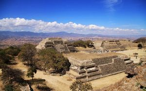
The territory of the Zapotec civilization was mainly concentrated on the hills of Monte Alban near Oaxaca, Mexico today. They leveled the mountaintop and built a plaza and several buildings scattered around the area. The plaza was surrounded by several buildings, with a platform to the north and south. In the center of the plaza, there were several small buildings, among which the arrow-shaped J Building is rare. Some people believe that it was used for astronomical purposes in ancient times.
On the southern plaza, there is a larger pyramid, while on the northern plaza, there are several scattered buildings, and a stone sculpture can be seen at the southwest corner of the plaza. The craftsmanship of the Zapotec civilization was very high, and the stone carving of the "Los Danzantes" dancers in Alben Mountain was very famous.
Coba: The Great Pyramid
Coba is a Mayan civilization archaeological site located 40 kilometers west of the Caribbean coast, 44 kilometers northwest of Tulum, and 90 kilometers east of Chichen Itza on the Yucatan Peninsula in Mexico.
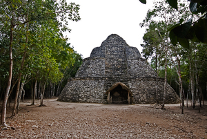
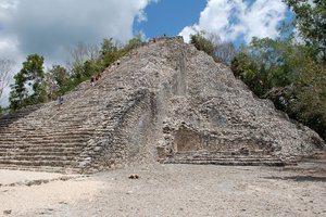
The area of this region covers about 80 square kilometers. Due to its remote location, Coba was not discovered until the late 20th century. It is estimated that there are about 6,000 buildings in total, but only about 5% of the ruins have been excavated.
Important buildings within the archaeological site include the Nohoch Mul, a large pyramid that stands 42 meters tall. This is one of the tallest structures in Maya civilization. The main buildings of Coba were built during the Classic period, between 500 and 900 AD. New buildings were constructed and ancient ones were repaired continuously until the arrival of the Spanish in the 14th century.
Chinese version: https://big5.zhengjian.org/node/75987